|
Categories
Accommodations & Reservations Airlines Alpine Ski Resorts Art Galleries Ballooning Beaches Boating Boat Cruises Boat Rentals & Marinas Calendar of Events Camping Car Rentals Carriage & Sleigh Rides Casino Resorts Concerts Cross Country Ski Resorts Fishing Fishing Charters Golfing Hiking Horseback Riding Jet skiing Kayaking Marinas Movie Theaters Mountain Biking Museums Parasailing Real Estate Restaurants River Rafting Road & Weather Conditions Sailing Shopping Sightseeing Ski & Snowboard Rentals Snowmobiling Snow Conditions Report Tennis Video Rentals Visitor Centers Waterskiing Weddings |
 Lake Tahoe. Information regarding distance and difficulty is provided below.
From Highway 28 on the north shore of Lake Tahoe, turn north on Reservoir Drive, just east of the old Tahoe Biltmore Casino. Turn right on Lakeshore Ave. and left on Forest Service Road 1601 (by the iron pipe gate). Park in the parking lot just below the lookout. volunteers. Superb views of the lake can be seen through the free telescopes located here. A short self-guided nature trail, located by the lookout, explains the history of the north shore of Lake Tahoe. Take Highway 28 from Highway 50 north approximately 2 miles. Look for an iron pipe gate on the west side of the highway. Park in one of the turnouts along the highway and do not block the gate. conifer forest with filtered views of Lake Tahoe along the way. Look for the remains of an old railroad grade along the way, built in the 1870's as part of the network to supply timber to Virginia City. When you reach a fork in the road, you have two options. The left fork leads to Prey Meadows which is blanketed with many varieties of wildflowers in the spring. The right fork leads you to Skunk Harbor, a small picturesque cove which offers great swimming and sunbathing in the summer.  Park at the Spooner Lake Trailhead, located in Lake Tahoe Nevada State Park, just north/west of the Highway 50/28 junction. A parking fee is charged. Dogs are allowed on a leash. North Canyon, lined with aspens, to Marlette Lake. This road provides access to the Flume Trail, a popular mountain biking trail, which starts at Marlette Lake Dam. No fishing is allowed at Marlette Lake because it is a fish hatchery. 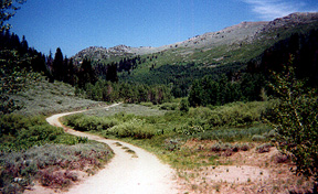 Take Highway 50 east approximately 1/2 mile from the junction of Highway 50 Park at the Spooner Summit Rest Area located along Highway 50. building. Several views of the Carson Valley as well as glimpses of Lake Tahoe can be seen along this forested trail. It is possible to climb Duane Bliss Peak (8,658'), South Camp Peak (8,866'), or Genoa Peak (9,150') by traversing cross country. Take Highway 431 (Mt. Rose Hwy.) north of Incline Village. Park at the trailhead located one mile south of the summit. offers excellent views of the lake, the city of Reno and the surrounding area. Follow a dirt road for three miles through a lodgepole cloaked forest interspersed with mule ears and sagebrush. In the spring, a lush meadow at the halfway point us filled with lupine, paintbrush and larkspur. The last two miles follow slippery switchbacks to the ridge line. Write your name in the log book located at the summit to show the world you made it! |
©2011 Certified Folder Display Service, Inc. All rights reserved.