|
|
Hiking Trails -
West Shore of Tahoe
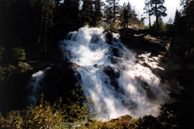
Photo of Eagle Falls
A topographic map and compass
are recommended for all hikes.
Weather conditions can change
rapidly Be prepared with the proper
clothing and equipment, food
and water, no matter how short the hike.
If you bring your pet on the
trail, put it on a leash to minimize its impact on
wildlife and other visitors.
Observe common courtesy and follow trail regulations.
Remember to practice minimum
impact camping and pack out what you pack in.
Backcountry users need to
obtain a Wilderness Permit for any hike into Desolation
Wilderness. Day hikers may
obtain a permit at the self-service stations
located at the trailheads. Overnight users must obtain a permit
and pay fees
in person from the Forest
Service office or Visitor Center.
REMEMBER...open campfires
are NOT allowed in Desolation Wilderness!
Three types of fees will be
tested in the Desolation Wilderness:
* a wilderness permit reservation
fee ($5)
* a overnight wilderness camping fee
($5/person/night w/3rd night
free or $30 individual annual pass)
* a parking fee at Eagle Falls Parking lot
($3/day/vehicle or $20/annual
pass)
The table below suggests several
trails located around the west shore of Lake Tahoe.
Information regarding distance
and difficulty is provided below. Following the table are
brief descriptions to the
trailheads. A topographic map and compass are recommended.
|
TRAILS
|
DIFFICULTY
|
ELEV. (Low/High)
|
MILES (One Way)
|
|
1. Cascade Creek Falls
|
Easy
|
6800'/6910'
|
1.0
|
|
2. Sugar Pine Point Nature Trails
|
Easy
|
Flat
|
0.7
|
| 3. Page Meadow |
Easy
|
Flat
|
No designated trail
|
| 4. Vikingsholm Trail |
Easy
|
6230'/6630'
|
1.0
|
| 5. Rubicon Trail |
Moderate
|
6230'/6580'
|
3.1 mi. to Emerald
Point
|
| 6. Meeks Bay Trail |
Moderate
|
6240'/8880'
|
4.5 mi. to Genevieve, 5 mi. to Craig, 5.7
mi. to Hidden, 5.9 to Shadow, 6.3 mi. to Stony Ridge, 8 mi. to
Rubicon |
| 7. Bayview Trail |
Strenuous
|
6910'/8440'
|
1 mi. to Granite, 4 mi. to Azure (x-co),
5 mi. to Dicks |
| 8. Eagle Falls |
Moderate
Strenuous
|
6600'/7000'
6600'/8500
|
4.5 to Dicks, Upper & Middle Velmas,
....5 mi. to Fontanillis |
1. CASCADE CREEK
FALL TRAIL:
Spectacular views of the 200 foot high falls and Cascade Lake
can
be seen from this short trail. For best viewing try springtime,
when runoff from snow melt is high. Take Highway 89 north from
South Lake Tahoe approximately 8 miles to the Bayview Campground
across from Inspiration Point. Parking is located at the far end
of
the campground.
2. SUGAR PINE POINT
STATE PARK NATURE TRAILS:
Contact state park rangers to obtain maps of the many trails
located here. The park charges a parking fee for day use. While
you're there don't miss a tour of the historic Ehrman Mansion.
Call (530) 525-7982 for more
information.
3. PAGE MEADOW:
In the spring, myriads of
beautiful wildflowers can be seen in this
large meadow. From Highway 89, two miles south of Tahoe City,
turn
on Pineland Drive. Turn right on Forest Service Road 15N60 or
16N48
to get to the area. There are no designated trails.
4. VIKINGSHOLM CASTLE:
View an authentic replica of a Viking castle. Daily tours are
given
from mid-June through Labor Day. A nominal fee is charged. Bring
a
picnic lunch and enjoy the fabulous view of Emerald Bay and
Fannette Island from the shoreline of this state park. Hike the
short trail to Lower Eagle Falls which begins directly across
from
the castle. Pets are not allowed. Take Highway 89 north from South
Lake Tahoe approximately 9 miles to the parking lot on the right.
The parking lot fills up quickly in the summer season, so arrive
early.
5. RUBICON TRAIL:
Dipping up and down along
the shoreline of Lake Tahoe, this trail
offers some of the most scenic views of the lake. Bring a swimsuit,
towel and picnic lunch to enjoy a sunny day at one of the many
quiet coves along the way. Take Highway 89 north 10 miles from
South Lake Tahoe to D.L. Bliss State Park. There is a fee for
day
use parking. Pets are not allowed.
6. MEEKS BAY TRAIL:
This moderate hike takes you along the northernmost part of the
unofficial Tahoe-Yosemite Trail. After following a road for
approximately 1.3 miles, the trail passes a small spring, parallels
Meeks Creek and continues upward into a forested valley. A chain
of
alpine lakes can be seen before the trail ascends 1,000 feet up
a
series of switchbacks leading to Phipps Pass. Take Highway 89
to
the Meeks Bay Resort. Parking is located across the highway from
the resort at a small dirt parking lot. Wilderness permit required.
7. BAYVIEW TRAIL:
Offering magnificent views of Emerald Bay and Lake Tahoe, this
steep trail leads you up the side of Maggie's Peak into Desolation
Wilderness. Stop at Granite
Lake for a short rest along the way. In
2.7 miles this trail intersects with the Eagle Falls Trail. Corral
and watering facilities for horses are available at the trailhead.
See "Cascade Creek Fall Trail" for directions. Wilderness
permit required.
8. EAGLE FALLS TRAIL:
Leading into the heart of Desolation Wilderness, this steep trail
offers majestic views of the Sierra high country. Just a 20 minute
walk, Eagle Lake is a popular short hike. A longer hike will lead
you to the three Velmas, Dicks, and Fontanillis lakes. Take Highway
89 north approximately 8 miles from South Lake Tahoe to Eagle
Falls
Picnic Area on the left. This is a very popular and congested
area.
Wilderness permit required.
Lake Tahoe Basin Management Unit
|